


trans4num - DST
The trans4num Decision Support Tool helps stakeholders explore landscape-scale solutions for reducing nutrient losses while supporting economically viable farming systems.
The green transition in agriculture requires decisions that work not only for individual farms, but for entire landscapes. The trans4num DST helps users test different strategies and visualize their environmental and economic impacts before decisions are made.
The challenge
Why is a new approach needed?
Agriculture across Europe faces growing challenges linked to:
- Nutrient losses to rivers, lakes, and coastal waters
- Soil degradation
- Water pollution
- Climate pressure on farming systems
Most nutrient management decisions are made at farm or field level. However, their environmental effects often appear at landscape scale.
This creates a major challenge: local decisions can lead to regional environmental problems.
At the same time, farmers, advisors, planners, and policymakers must balance:
- environmental goals,
- economic viability,
- food production,
- and practical farming realities.
The trans4num project identified the need for a tool that helps stakeholders work together to explore realistic and collaborative solutions.
What is the trans4num DST?
A tool for collaborative landscape planning
The trans4num Decision Support Tool (DST) is a spatial and data-driven planning tool that helps users explore how different agricultural management strategies influence:
- nutrient losses,
- water quality,
- crop production,
- farm economics,
- and broader environmental outcomes.
The tool focuses on landscape-level impacts rather than individual farms in isolation.
Important:
The outputs of the DST must not be seen as prescribed decisions. Instead, it helps stakeholder to jointly explore:
- regional envrionmental targets (optimization goal),
- aleternative scenarios to the status quo,
- visualization of trade-offs,
- and identify practical pathways forward.
Who is it for?
The DST is intended for groups working on regional or landscape-level planning, including:
- Policymakers
- Regional authorities
- Environmental agencies
- Water managers
- Advisors and extension services
- Farmer groups and cooperatives
- Researchers and students
The tool supports dialogue between different stakeholders and encourages collaboration around Nature-based Solutions (NbS).
How does the tool work?
The DST guides users through a four-step process that enables them to select goals and constraints from a predefined set of options. Based on these inputs, the DST generates outputs that support identifying an optimal allocation of NbS across the landscape. The tool must be configured for each specific region and use case by defining relevant optimization objectives and integrating the necessary underlying data.
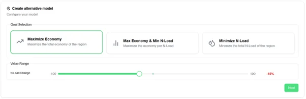
Step 1: Define a goal
Users begin by selecting an optimization goal, for example:
- Maximize economic performance while reducing nitrogen losses by x kg/ha
- Minimize nitrogen losses to coastal waters
- Find the best balance between productivity and N loss reduction
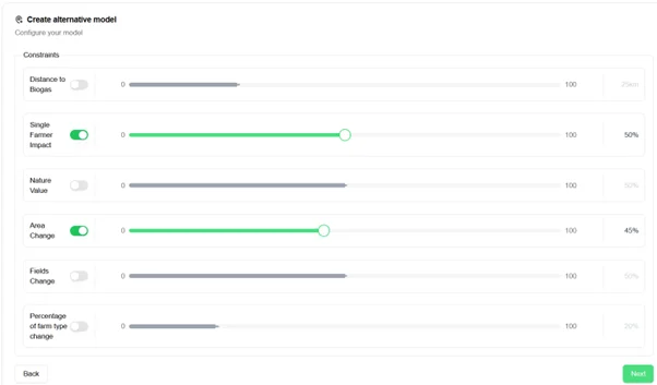
Step 2: Add constraints
Users can then define practical limits or conditions, such as:
- Limiting distance to relevant bioindustry (biogas plant, composting facility etc.)
- Maintaining realistic farm types,
- Restricting certain crop changes,
- Respecting environmental regulations.
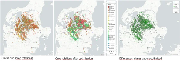
Step 3: Generate alternative scenarios
The tool calculates possible landscape configurations that could help achieve the selected goals.
Step 4: Explore the results
The DST visualizes outcomes through:
Interactive maps, showing on a field-plot base changes between status-quo and the optimized solutions in terms of
- crop rotations
- nitrogen losses,
- yields,
- economic returns.
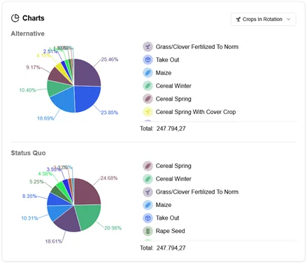
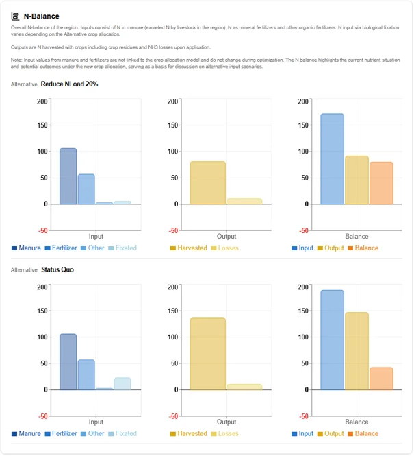
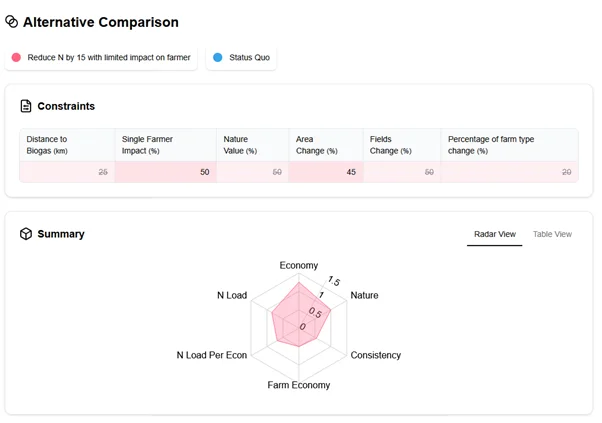
Charts and summaries, comparing regional indicators before and after optimization, including:
- crop production shares,
- nitrogen loss,
- consistency of the landscape,
- farm and regional economy,
- the overall nitrogen balance of the region.
What makes trans4num DST different?
- Landscape-scale thinking
Most agricultural tools focus on individual farms. The trans4num DST instead evaluates how decisions interact across an entire region.
- Spatial intelligence
Results depend on geographic conditions such as: soil type, proximity to sensitive water bodies, nearby bioindustries, and environmental characteristics.
- Supports Nature-based Solutions
The tool has a flexible structure and can evaluate a range of strategies such as: diversified crop rotations, perennial crops, catch crops, bio-based fertilizer, composting and circular nutrient flows.
- Encourages collaboration
The DST is designed to support discussions between stakeholders and identify shared solutions.
The Danish prototype
The first DST prototype was developed for the Limfjord region in Denmark.
- Main objective: Reduce nitrogen losses to coastal waters while maintaining regional economic performance.
- Nature-based Solutions tested: increased use of perennial grass, catch crops, green biorefining opportunities, and alternative crop rotations.
The tool identifies where these strategies could be most effective across the landscape.
Testing and stakeholder feedback
The DST has been tested with farmers, advisors, regional planners, and agricultural experts.
Early-stage workshops in Denmark contributed to improving the tool’s usability, the realism of farming scenarios, and the communication of results. One key lesson learned was that effective facilitation and accessible communication are essential for meaningful stakeholder engagement.
Follow-up workshops in Hungary, the Netherlands, and the UK, where the Danish prototype was demonstrated, showed that the tool can function as a boundary object to support stakeholder dialogue on the adoption of Nature-based Solutions (NbS) for more sustainable agricultural production across diverse settings. The workshops further highlighted that, although the tool is adaptable to different agricultural and governance contexts, successful deployment depends on enabling governance structures, the availability of spatial data, and the capacity to quantify NbS effects in relation to regional optimization targets.
Intellectual property and access rights
The model engine underlying the DST is designed to be modular and versatile, enabling customization to new use cases. To support transparency and future development, the codebase of the model engine is openly accessible on GitHub, together with comprehensive documentation, allowing researchers and software developers to extend and further develop the tool in the future.
The frontend, including its source code, remains the intellectual property of ICOEL. During the lifetime of the trans4num project, maintenance of the DST will be the responsibility of the project consortium. Following the completion of the project, the web-based interface will remain operational but will be protected by password authentication. Access to the trans4num DST may be requested from ICOEL and can be provided free of charge to users with a genuine research or professional interest. The tool is available under https://trans4num.cordulus.com/.
Further maintenance and continued development of the DST will be carried out within the framework of the PlantPerform project, through a collaboration between AU, ICOEL, and CO.
The dataset used in the Danish case study is owned and maintained by AU and is shared with ICOEL, CO, and FiBL for the purposes of the project and related research activities.
DST Team
AARHUS UNIVERSITY
Prof. Dr. Tommy Dalgaard

CORDULUS
Morten Birk

FiBL
Hanna Frick

ICOEL
Anton Rasmussen

KLIMAFONDEN SKIVE
Anne-Mette S. Langvad